New Zealand tramp: Wills River - Wilson Pass - Hunter River - Scrubby Flat Creek -
Makarora River - Haast Pass
According to the weather forecast my tramp would be just about entirely through rain.
But it turned out a lot better: two days of rain and snow and three with beaut
weather.
Even though I left Dunedin in good time and arrived in Wanaka in less than 4 hours
travel, the road from there to Haast Pass is not particularly easy to travel on, so
that it was past 1pm in the afternoon when I finally got my backpack on and hit the
track. A nice New Zealand couple in a campervan had seen me sneak my bike into the
bushes at Haast Pass and seeing me now disappear into the bush at the Gates of
Haast wished me the best of luck. The woman of course asked with concern whether
I had sufficient warm clothing. I may have looked a bit scantily dressed on this
rainy and windy day, though by now it had petered out to a drizzle. Nevertheless within
a few minutes on the track I was warm enough. I also got my first important
lesson quite early when I slipped on a large rock and sat down unceremoniously: don't
trust wet rocks.
 The whole track was quite slippery. The more recent parts of
the track where detours had been made around slips were certainly a lot more
awkward, than the more established route. At one stage I had to walk along
roots on a wall while holding to some more roots at eye-level. There's also a
ladder, leading the track onto a ledge. Like so many rivers in this part of the
Southern Alps, the Wills River has wide open flats further up-river and then makes its
way through a gorge before joining another major river valley , in this case
the Haast River. There are tracks in the lower reaches through the more
gorge-like valley, where travel through bush and scrub would otherwise be very difficult.
I expected to reach Wills Hut within about 5 hours, so was pleasantly
surprised when I realised my good progress and popped out onto the
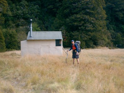
open flats. I was at the hut before 4pm. It sits at the edge of a grassy
river flat right beside a small stream. I made myself busy chopping
wood and then had a lazy evening reading and trying to get the fire going.
The whole track was quite slippery. The more recent parts of
the track where detours had been made around slips were certainly a lot more
awkward, than the more established route. At one stage I had to walk along
roots on a wall while holding to some more roots at eye-level. There's also a
ladder, leading the track onto a ledge. Like so many rivers in this part of the
Southern Alps, the Wills River has wide open flats further up-river and then makes its
way through a gorge before joining another major river valley , in this case
the Haast River. There are tracks in the lower reaches through the more
gorge-like valley, where travel through bush and scrub would otherwise be very difficult.
I expected to reach Wills Hut within about 5 hours, so was pleasantly
surprised when I realised my good progress and popped out onto the
open flats. I was at the hut before 4pm. It sits at the edge of a grassy
river flat right beside a small stream. I made myself busy chopping
wood and then had a lazy evening reading and trying to get the fire going.
Maybe my good progress on the first day made me a little bit too relaxed, as
I had no concern about the long tramp on the next day. Maybe that's why I left
at the fairly late time of 8am. It was still drizzling and I
noticed that snow had fallen on the higher slopes. At first I could
travel along easy flats, but then it continued to get more difficult, especially since
I wasn't keen on crossing the river too often. Even though it clearly had been higher
some time ago, it still seemed to carry plenty of water. That meant that I
had to pick a few detours through the bush. As I got higher up the valley, travel
got more difficult and I resorted to bush bashing more often. This took plenty of
time and energy. As a result I reached the bush line much later
than expected and very exhausted, so that I had to have lunch.
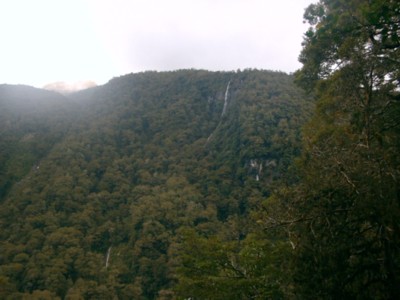
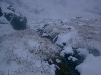
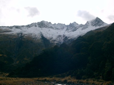
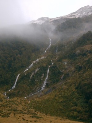 Up here the views were quite spectacular with waterfalls dashing off the
mountains and white peaks rearing eerily into swirling clouds. Higher up
the valley (approximately 1200m above sea-level) the tussock and rocks
were covered with snow, and by now it had started snowing again.
Up here the views were quite spectacular with waterfalls dashing off the
mountains and white peaks rearing eerily into swirling clouds. Higher up
the valley (approximately 1200m above sea-level) the tussock and rocks
were covered with snow, and by now it had started snowing again.
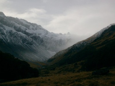 Travel
became harder across the rocks and visibility became quite low. I briefly
thought about turning back but the thought of bashing through all that
bush again drove me onward. Luckily the route to Wilson Pass in the
upper reaches was not quite that obvious so that Moir's Guide Book
contained a relatively detailed description which I could follow even
without seeing too far. Along a creek I reached a tussock
ledge and made my way up to the pass through a winter wonderland
of snow. I actually reached the pass quite quickly and was elated. But the
strong biting wind and snow flurry up there didn't give me the opportunity for a
photo stop. With some of the snowdrifts half a metre high, it wasn't easy going
either. I soon descended on the other side and the wind subsided.
Travel
became harder across the rocks and visibility became quite low. I briefly
thought about turning back but the thought of bashing through all that
bush again drove me onward. Luckily the route to Wilson Pass in the
upper reaches was not quite that obvious so that Moir's Guide Book
contained a relatively detailed description which I could follow even
without seeing too far. Along a creek I reached a tussock
ledge and made my way up to the pass through a winter wonderland
of snow. I actually reached the pass quite quickly and was elated. But the
strong biting wind and snow flurry up there didn't give me the opportunity for a
photo stop. With some of the snowdrifts half a metre high, it wasn't easy going
either. I soon descended on the other side and the wind subsided.
 It was actually
quite fun at first sliding down the slopes - until my expensive pants ripped,
that is.
It was actually
quite fun at first sliding down the slopes - until my expensive pants ripped,
that is.
By now it was obviously clear that I wouldn't reach the next hut in daylight, so
I tried to get to the start of the marked track before daylight faded.
 Unfortunately
with the poor visibility I found it a bit hard to orientate myself. Nevertheless at
some point I struck a lone warratah and followed a track for a while
(though that certainly was not "the track"), but lost it. When I came to
the bush edge, I searched frantically for the track entrance: it was now getting
dark and I used my head torch. Crashing through scrub I achieved nothing
except of further damaging my pants and losing my drink bottle. Finally I
decided the best thing was to settle down for the night, especially since it
was now completely dark and even if I found the track, still more than 2 hours
through demanding bush. I went and plonked down under some scrubby trees, where I
hoped it would be relatively dry, windstill and without falling branches and
the ground not too steep. I sucked some sweets and then
melted some snow on my gas cooker to get some soup cooking. There was
no wind at all here, so I didn't have any problems. It was nice to get
something warm into the tummy. Unpacking my backpack I stowed
most things in a few plastic bags, hung up my jacket and trousers
on a tree and put whatever else had to be kept dry with my sleeping
bag into the packliner. In nice dry clothes I crept into the
sleeping bag. Those packliners are good things, but unfortunately
a bit small for me, so that my shoulders stuck out into the
cold. My beanie provided an excellent pillow and sleeping
cap. It continued to snow lightly, but only the occasional
drop fell on me. By 3 am I noticed the clear starry sky. Of course
I hardly slept, but do distinctly remember dreams of tracks clearly marked
with orange triangles.
Unfortunately
with the poor visibility I found it a bit hard to orientate myself. Nevertheless at
some point I struck a lone warratah and followed a track for a while
(though that certainly was not "the track"), but lost it. When I came to
the bush edge, I searched frantically for the track entrance: it was now getting
dark and I used my head torch. Crashing through scrub I achieved nothing
except of further damaging my pants and losing my drink bottle. Finally I
decided the best thing was to settle down for the night, especially since it
was now completely dark and even if I found the track, still more than 2 hours
through demanding bush. I went and plonked down under some scrubby trees, where I
hoped it would be relatively dry, windstill and without falling branches and
the ground not too steep. I sucked some sweets and then
melted some snow on my gas cooker to get some soup cooking. There was
no wind at all here, so I didn't have any problems. It was nice to get
something warm into the tummy. Unpacking my backpack I stowed
most things in a few plastic bags, hung up my jacket and trousers
on a tree and put whatever else had to be kept dry with my sleeping
bag into the packliner. In nice dry clothes I crept into the
sleeping bag. Those packliners are good things, but unfortunately
a bit small for me, so that my shoulders stuck out into the
cold. My beanie provided an excellent pillow and sleeping
cap. It continued to snow lightly, but only the occasional
drop fell on me. By 3 am I noticed the clear starry sky. Of course
I hardly slept, but do distinctly remember dreams of tracks clearly marked
with orange triangles.
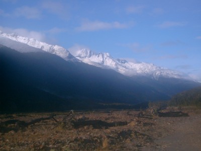
The next morning I was on my way as soon as light dawned. I crashed
down to the river and hopped along the boulders. I was again gently
reminded to keep those slippery rocks in mind. In the hope of striking
the track I went up a creek bed and indeed came upon one of those
big orange triangles: I had found it! From here the track was
 clearly marked and easy to follow, gently leading down to the Hunter
Forks through nice bush. I did find the river crossing at the
forks a bit difficult, but got over to the other side. When I came
out of the bush, the sun shone brilliantly and I could see the peaks
in glistening white. Along the river flats I traveled to Forbes Flats Airport. It
even has its own terminal building, otherwise known as Forbes Hut. It's a
nice place, but was in the shade in the morning. Nevertheless I had breakfast
there, as I only had had a snack earlier. Luckily somebody also had
left behind a drink bottle in the hut, so that I thankfully
replaced my lost one.
clearly marked and easy to follow, gently leading down to the Hunter
Forks through nice bush. I did find the river crossing at the
forks a bit difficult, but got over to the other side. When I came
out of the bush, the sun shone brilliantly and I could see the peaks
in glistening white. Along the river flats I traveled to Forbes Flats Airport. It
even has its own terminal building, otherwise known as Forbes Hut. It's a
nice place, but was in the shade in the morning. Nevertheless I had breakfast
there, as I only had had a snack earlier. Luckily somebody also had
left behind a drink bottle in the hut, so that I thankfully
replaced my lost one.
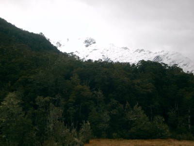
The track along the Hunter River was easy to follow, especially since
only three days before cattle had been herded down the river. It is a
nice valley with plenty of quaint huts, though I think a number of
them will soon be removed. I arrived at Ferguson Hut at around
2pm and proceeded to empty my entire backpack. Just about everything
was wet to some degree from the walk through the snow and the night
under the trees.
 There's a nice fence in front of the hut which was soon
covered with my belongings. After lunch I sat in the sun, reading a book
and watching the clothes dry. The insect repellent came in handy for
that: Unfortunately the sun soon disappeared behind some clouds. I cut some
wood and took the afternoon slowly. In the evening I got the open fire going, read
a bit and went to bed early. With the logs crackling in the open fire
place I went to sleep. This is a beaut hut with the water tank
just outside the door and the toilet down in the bush, so that one does
not have to walk through long wet grass to get there.
There's a nice fence in front of the hut which was soon
covered with my belongings. After lunch I sat in the sun, reading a book
and watching the clothes dry. The insect repellent came in handy for
that: Unfortunately the sun soon disappeared behind some clouds. I cut some
wood and took the afternoon slowly. In the evening I got the open fire going, read
a bit and went to bed early. With the logs crackling in the open fire
place I went to sleep. This is a beaut hut with the water tank
just outside the door and the toilet down in the bush, so that one does
not have to walk through long wet grass to get there.
After a long sleep I got up before 6am ready for another
big day. Somehow I seem to take my time to get ready in the
morning, especially if I need to totally repack my backpack. So I got
away just after seven. In the dim light I came upon some cattle who
must have been left behind a few days earlier and now ran ahead
of me for a while.
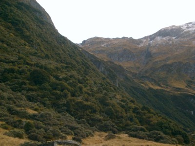
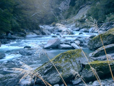
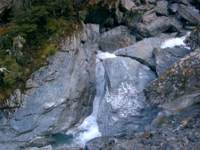 Crossing an arm of the braided Hunter River a few times I
came to Scrubby Flat Creek. This creek leads far into the mountains from
the main river valley. A marked route leads up the lower reaches of the creek
where it flows through steep gorge-like mountainsides. The track is quite
steep itself and I was glad I was going up and not trying to descend it. Two fantails
accompanied me for about an hour, chirping around my head. The track stops
quite abruptly and I had to sidle along gravel and scrub slopes above the creek. It
took me some time before I reached the open flats further on. Travel here
is quite easy and really inspiring among those high mountains.
Crossing an arm of the braided Hunter River a few times I
came to Scrubby Flat Creek. This creek leads far into the mountains from
the main river valley. A marked route leads up the lower reaches of the creek
where it flows through steep gorge-like mountainsides. The track is quite
steep itself and I was glad I was going up and not trying to descend it. Two fantails
accompanied me for about an hour, chirping around my head. The track stops
quite abruptly and I had to sidle along gravel and scrub slopes above the creek. It
took me some time before I reached the open flats further on. Travel here
is quite easy and really inspiring among those high mountains.
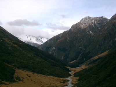
 As I got further
along the creek I could also clearly see the pass and tried to pick
a route up to it. The weather had become really good and only
a few clouds wafted along the higher peaks. I only wore my jacket during
lunch and a few minutes after that. After lunch I went further along
the flats and along one of the tributaries of Scrubby Flat Creek to ascend
a ridge. I was surprised at how little I had to bash through scrub.
As I got further
along the creek I could also clearly see the pass and tried to pick
a route up to it. The weather had become really good and only
a few clouds wafted along the higher peaks. I only wore my jacket during
lunch and a few minutes after that. After lunch I went further along
the flats and along one of the tributaries of Scrubby Flat Creek to ascend
a ridge. I was surprised at how little I had to bash through scrub.
 I quite
like this tramping in open country.
I quite
like this tramping in open country.
To the minute exact I reached the Scrubby Flat Creek Pass
at 14:30. At a height of 1570m there were only a few remaining
pockets of snow here.
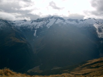
 Views were great and the wind wasn't too bad. I soon
descended steep tussock slopes to reach the bush line. Here I had to follow
a ridge down to the Makarora River. There's no track or route here, but
the bush is not too dense. I sometimes had to retrace my step and at
one stage stood at a the top of a 15m-high cliff.
Views were great and the wind wasn't too bad. I soon
descended steep tussock slopes to reach the bush line. Here I had to follow
a ridge down to the Makarora River. There's no track or route here, but
the bush is not too dense. I sometimes had to retrace my step and at
one stage stood at a the top of a 15m-high cliff.
 Also I had
to continually keep between the two streams which descend the
mountain through a series of chasms. It's also quite pleasant walking
on the soft forest floor and not hitting the hard track, especially going
down-hill it makes it that much easier on the knees. I reached Makarora Hut
at 5.15pm, though I had could have walked the last 20 minutes in half that
time, if I had been keen.
Also I had
to continually keep between the two streams which descend the
mountain through a series of chasms. It's also quite pleasant walking
on the soft forest floor and not hitting the hard track, especially going
down-hill it makes it that much easier on the knees. I reached Makarora Hut
at 5.15pm, though I had could have walked the last 20 minutes in half that
time, if I had been keen.
 Again I occupied myself in gathering and
cutting wood for those coming after me. Not that many people come
here: Only 15 persons had stayed in the hut in the past year. I cooked my
most elaborate meal yet: rice with vegetable and cheese sauce.
Again I occupied myself in gathering and
cutting wood for those coming after me. Not that many people come
here: Only 15 persons had stayed in the hut in the past year. I cooked my
most elaborate meal yet: rice with vegetable and cheese sauce.
Clouds covered the valley when I set out the next morning. I soon
left the flats behind and started on the track. I had read a
bit about this track in the hut book with some calling it "hard", others "good",
some "dangerous" and somebody remarking that it's "nice, but difficult
enought to keep the idiots out". Well, I certainly wouldn't recommend
anybody brining their children out here for their first experiences
of a bush walk. It is challenging and certainly nothing for short legs. In parts
it is very steep, in others very narrow with decent drops to one side. One certainly
needs sure footing. At one point the track goes along a cliff
and is less than two boots wide (i.e. you couldn't put one foot beside the other) with
a drop of 10 to 15m; and if you were to fall that distance better
hold on quick because there's another 50m to go down to the river from there. As it
was a bit drier that day, I did find it less slippery than my tramp on the
first day.
 Just before 11 I met the first people since setting out
on Tuesday. They passed me very quickly on the track and seemed to be
equipped with the latest and most fashionable gear available including those
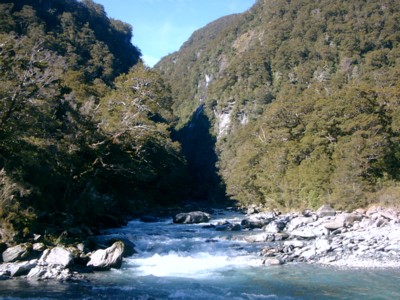
cool Nordic walking poles. The Makarora River here flows through a wild, wild gorge
and the track goes over the hillside to rejoin it later on. This means
a bit more of hill-climbing.
Just before 11 I met the first people since setting out
on Tuesday. They passed me very quickly on the track and seemed to be
equipped with the latest and most fashionable gear available including those
cool Nordic walking poles. The Makarora River here flows through a wild, wild gorge
and the track goes over the hillside to rejoin it later on. This means
a bit more of hill-climbing.
 According to the sign, this track takes
7 hours, but I did it in under 5 including lunch and leisurely
morning tea, otherwise about 4.
According to the sign, this track takes
7 hours, but I did it in under 5 including lunch and leisurely
morning tea, otherwise about 4.
At Davis Flat I crossed the Makarora River which is quite
shallow here and then walked along the Bridle Track. This is a metalled track
with easy grades, bridges and the whole gadgets. It is quite wide, but nevertheless
goes along some quite steep drops. I had left my bike at Haast Pass and
was glad to still see it there unharmed. Leaving my backpack in the
bush, I pedalled my way down the road to the Gates of Haast, where I had left
my car. I have to say I felt quite uncomfortable doing that. The road is quite
narrow and I could so easily have been hit by a car. It's also quite steep in
parts and ever since one snapped on Ravensbourne hill (though without serious
consequences) I'm not trusting my brakes too much. I rather tramp through some
challenging territory than rely on the alertness of my fellow man. When I packed
my bike into the car I saw one of those tourists with his fully-laden bike go
down the road. Good luck! Have they still not realised that New Zealand is not
really bike-friendly? I'd rather walk long distances through it.
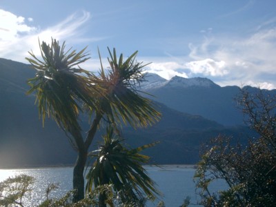
I enjoyed Lakes Wanaka and Hawea this time, stopping at a few
places.
 I had tea at a restaurant in Kurow where I was the only
dine-in customer, sitting just a table away from the cat's favourite
chair. When I came home, I listened to the news, but it was still the same old story.
I had tea at a restaurant in Kurow where I was the only
dine-in customer, sitting just a table away from the cat's favourite
chair. When I came home, I listened to the news, but it was still the same old story.